POLSCAT Observes High Spatial and Temporal Variability of Coastal Ocean Wind
Simon H. Yueh
tel, 818-354-3012; fax, 818-393-3077; email: simon.yueh@jpl.nasa.gov
The Jet Propulsion Laboratory (JPL) polarimetric scatterometer (POLSCAT)
is an airborne microwave radar operating at 13.9 GHz, designed to measure VV, HH, VH, and HV polarized radar
response of ocean surfaces. It was developed to demonstrate the polarimetric radar
technique for ocean wind measurements with unique wind direction determination
capability. POLSCAT was deployed on the National Center for Atmospheric
Research (NCAR) C-130 aircraft for proof-of-concept flights in August 2000.
Several flights over the Monterey Bay Aquarium Research Institute buoys were
completed with the successful demonstration of polarimetric wind scatterometer
concept (Yueh et al, in press).
POLSCAT was flown on the NASA DC-8 together with the JPL airborne synthetic
aperture radar (AIRSAR) on 17 February 2002 to acquire ocean surface wind off
the coast of Santa Monica and Santa Barbara, California. The POLSCAT surface
wind data will facilitate the interpretation of ocean current inferred from the
AIRSAR along track interferometry. Two sets of flight lines were performed with a
time separation of about 4 hours. The surface wind speed was retrieved from the
POLSCAT radar data using the QuikSCAT geophysical model function together
with the wind direction observations made by nearby ocean buoys. The wind was
from the west during the DC-8 flights. The retrieved wind speeds are illustrated in
Figures 1 and 2 with the start time labeled against each flight line.
The shadowing effects of the Santa Cruz and Catalina islands on the surface wind
were apparent in Figure 1 (16:38 UT and 16:58 UT lines). The POLSCAT wind
speed on the leeward side of the islands appeared weaker than the wind speed over
other portions of the flight lines. The shadowing effects were most obvious near
the Santa Cruz Island with the wind speed approaching as low as 1 m/s to the east
of island in comparison with 4-6 m/s in adjacent areas (mid- and lower-right panels
in Figure 1). Additional, there was a strong wind gradient near Santa Barbara
(17:53 UT flight line, upper-right panel in Figure 1), which could also be a result
of land surface topography (mountain range from Point Conception to Santa Barbara).
The high temporal variability of surface wind is indicated by the data from a set of
repeated flight lines near Santa Monica, performed about 4 hours after the first set.
Comparing the wind speed data plotted in Figures 1 and 2 shows a dramatic
increase of wind by about 3-5 m/s from the morning to the afternoon off the coast
of Santa Monica. This dramatic change could be related to the weather system
passing through the southern California in the morning of February 17.
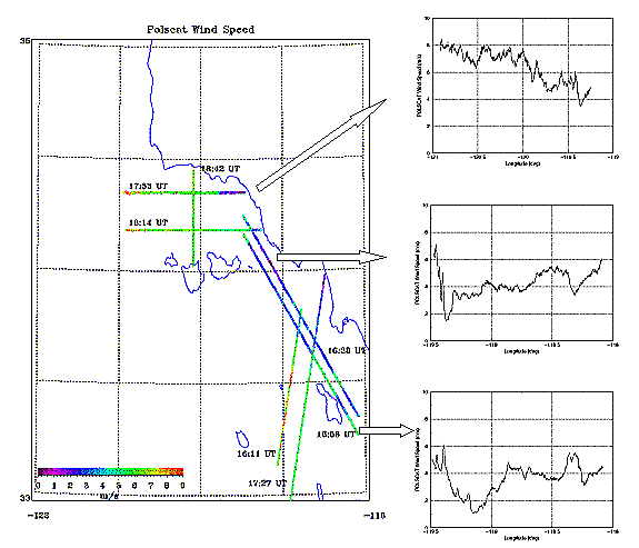
Figure 1:
POLSCAT wind from 7 flight lines off the coast of santa barbara and Santa Monica,
California on 17 February 2002 indicates the high spatial variability of winds in
coastal areas.
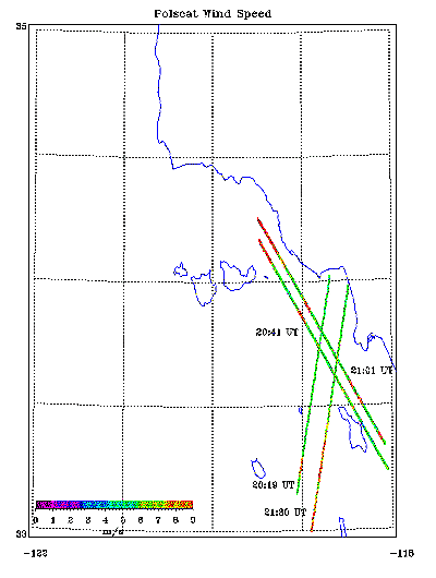
Figure 2:
POLSCAT wind from 4 flight lines off the coast of Santa Monica, California on 17
February 2002.
Reference
Yueh, Simon H., W. J. Wilson, and S. Dinardo, Polarimetric Radar Remote Sensing of Ocean
Wind, IEEE Trans. Geoscience and Remote sensing, in press.
|