POSSIBLE ENSO TELECONNECTION
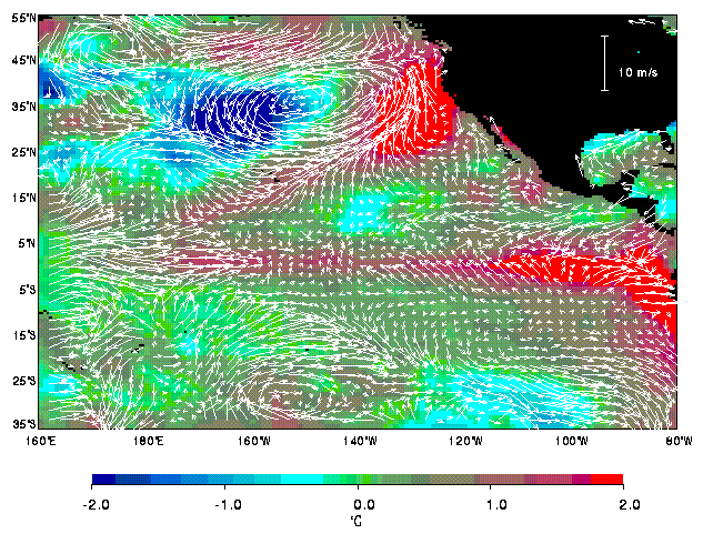
Surface wind anomalies (white arrows) are superimposed on this color map of sea-surface temperature
(SST) anomalies. The surface wind data are derived from NSCAT, and the SSTs are from
observations by the Advanced Very-High-Resolution Radiometer blended with in situ measurements.
Data are averaged over the last 10 days of May 1997. Warming along the equator is
part of the El Niño condition and is related to the westerly wind anomalies and the relaxation of
trade winds over the equatorial Pacific. The equatorial westerly wind anomalies are connected to the
anomalous cyclonic wind pattern in the northeast Pacific. The warming along the west coast
of the United States is the result of the movement of the pre-existing warm SST anomalies
with the cyclonic wind anomalies toward the coast. Winds from the tropical ocean bring heat
and moisture, and suppress evaporative cooling; associated clouds may also block solar heating.
The opposite is true for winds from the north. In 1997, the subtropical high-pressure system
off the Mexican coast was displaced by a low-pressure system and the associated southerly winds;
upwelling of cold water was supressed.
[From Liu, W.T., W. Tang, and H. Hu, 1998: Spaceborne sensors observe El Niño
Effect on Ocean and Atmosphere in North Pacific. Eos Trans. of Amer. Geophys. Union, 79, 249 & 252.]