Global Coverage and Detailed Structure of Hurricane Floyd
W. Timothy Liu, NASA Jet Propulsion Laboratory
The image is a synoptic view of the distribution of ocean surface winds over the Atlantic Ocean derived from objective interpolation of the observations by SeaWinds on QuikSCAT, at the standard resolution of 25 km. White streamlines indicating wind direction are superimposed on the color image of wind speed. The averaged normalized backscatter coefficients over land, which is an indication of vegetation cover, and over Polar Regions, which represents ice-morphology and sea-ice extend, are also added.
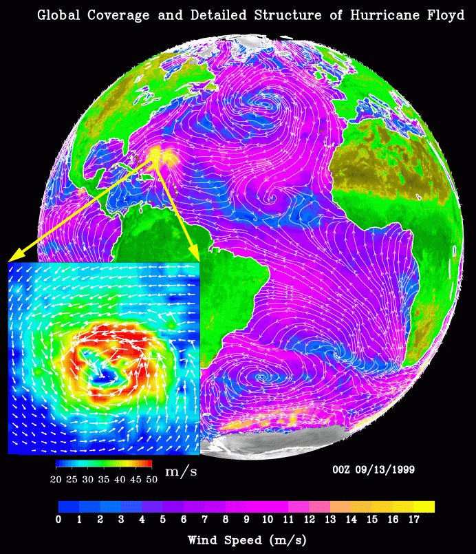 Over the ocean, the strong (violet) trade winds blow steadily from
the cooler subtropical oceans to the warm water of the Intertropical
Convergence Zone (ITCZ) located just north of the equator; the trade wind
is clearly discernable in the South Atlantic. Both the
convergence area at the ITCZ and the divergence area at the horse
latitudes are indicated by low wind speed of blue color. In the
midlatitudes, the high vorticity caused by the rotation of
the Earth generates the spirals of weather systems. The North
Atlantic is dominated by a high-pressure system, whose anticyclonic
(clockwise) flow creates strong winds blowing parallel to the
coast of Spain and Morocco, creating strong ocean upwelling. Hurricane
Floyd, with its high winds (yellow) is clearly visible east of the
Bahamas. Tropical depression Gert is forming in the tropical
mid-Atlantic (as an anticlockwise spiral) and will
develop into a hurricane later.
Over the ocean, the strong (violet) trade winds blow steadily from
the cooler subtropical oceans to the warm water of the Intertropical
Convergence Zone (ITCZ) located just north of the equator; the trade wind
is clearly discernable in the South Atlantic. Both the
convergence area at the ITCZ and the divergence area at the horse
latitudes are indicated by low wind speed of blue color. In the
midlatitudes, the high vorticity caused by the rotation of
the Earth generates the spirals of weather systems. The North
Atlantic is dominated by a high-pressure system, whose anticyclonic
(clockwise) flow creates strong winds blowing parallel to the
coast of Spain and Morocco, creating strong ocean upwelling. Hurricane
Floyd, with its high winds (yellow) is clearly visible east of the
Bahamas. Tropical depression Gert is forming in the tropical
mid-Atlantic (as an anticlockwise spiral) and will
develop into a hurricane later.
The ocean is largely covered by clouds, which prevent observations of the sea surface, by instruments measuring at infrared and visible frequencies. Because the atmosphere is largely transparent to microwaves, SeaWinds was able to cover 93% of the global oceans, under both clear and cloudy conditions, in a single day, with the capability of synoptic view of the ocean. The high space resolution of the data also gives detailed description of small weather systems, like Hurricane Floyd. The insert is based on data specially produced at 12.5 km. In the insert, white arrows of wind vector are imposed on the color image of wind speed. The insert represents a 3-degree area occupied by Hurricane Floyd.
The image is from a peer-reviewed book chapter: Liu, W.T., and K.B. Katsaros, 2001: Air-Sea Flux from Satellite Data. Ocean Circulation and Climate. Chapter 3.4., 173-179, G. Siedler and J. Church (eds), Academic Press, New York.
The normalized backscatter data over land and ice were provided by David Long, and the high resolution data over Hurricane Floyd were provided by Simon Yueh. Xiaosu Xie and Hua Hu produced the computer graphic.