RESPONSE TO HYDROLOGIC FORCING

Over the ocean, ground-based measurement of precipitation (P) is extremely
spotty and quite unreliable, and there is practically no direct
measurement of evaporation (E). In the past, large
scale fresh water flux into the ocean F=P-E was estimated
using conservation principal. F is equated to the horizontal divergence of
the vertically integrated water vapor transport, the computation of which requires
measurements of vertical profiles of wind vector and humidity in
the atmosphere. The NASA scatterometer (NSCAT), designed to measure ocean surface
wind vectors at 25 km resolution, was launched on the Japanese
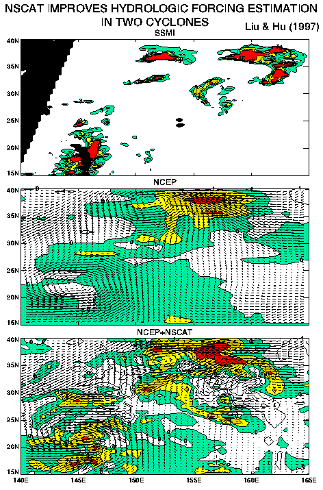
Satellite ADEOS-1. On September 15, the first day of routine operation, NSCAT observes
Typhoon Tom south of Japan and a midlatitude cyclone east
of Japan. Data from the Special Sensor Microwave Imager (SSMI) show heavy
precipitation in the core of the typhoon and in the frontal
areas of the midlatitude storm. Computation of F, using wind and
humidity profiles of the reanalysis of model results from the National Center of
Environment Prediction (NCEP) fails to identify the typhoon and misses
the frontal structure of the mid-latitude cyclone. It is
apparent that the coarse spatial resolution of the NCEP products is insufficient to
resolve small-scale weather systems. By replacing the first level wind of NCEP
data with NSCAT winds, the resultant F pattern is in better agreement
with the SSMI rain patterns, and clearly reveals the spiral structures
of the two storm. Typhoon Tom later merged with the midlatitude storm and
NSCAT monitored the extratropical transition. The study demonstrates that
spaceborne scatterometers improve the estimation of the hydrologic
balances in storms. The influence of NSCAT winds is not confined to
the surface, but will be felt throughout the atmospheric column,
because of mass conservation.

